article thumbnail

How to Calculate Density Altitude (Without a Math Degree)

Pilot Institute

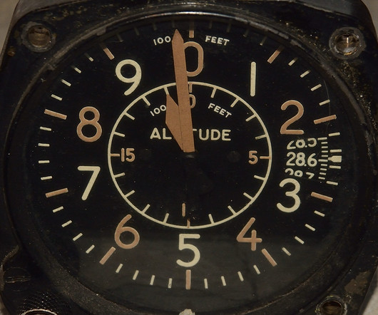
Types of Altitude To fundamentally understand density altitude, you need to understand the five types of altitude used in aviation: Indicated altitude: the altitude read on the altimeter (regardless of altimeter setting) Pressure Altitude: the indicated altitude of the altimeter when it is set to 29.92 Press ENTER. Press ENTER.

article thumbnail

How to Read METAR and TAF Reports

Pilot Institute

Altimeter Pressure (A2990) The next part of the report indicates the local atmospheric pressure, measured in inches of mercury (inHg). Pilots use this value to adjust their altimeters, ensuring they display altitude as close to mean sea level (MSL) as possible. Its also possible to report negative temperatures with an M prefix.

AGL
Insiders

Sign Up for our Newsletter

This site is protected by reCAPTCHA and the Google Privacy Policy and Terms of Service apply.

Trending Sources

article thumbnail

Trial by Ice

Air Facts

Our NIFA team of pilots would travel to other colleges and compete in sanctioned competition involving precise navigation, pre-flight inspections, accuracy landings, and simulated bomb drops into a barrel from 100 AGL feet using bean bags as bombs. How can this be? There was absolutely no forecast for freezing rain this far north!

VOR
article thumbnail

Sporty’s Most Frequently Missed Test Questions—June 2025

Flight Training Central

Based upon the altitude indicated by altimeter #3, which course direction is appropriate for this VFR cruising altitude? The minimum flight visibility required for VFR flights above 10,000 feet MSL and more than 1,200 feet AGL in controlled airspace is 5 miles. South-Southeast North-Northeast Southwest Correct! 180°-359° magnetic.

VOR
article thumbnail

Practicing Steep Turns: Techniques to Improve Pilot Control and Precision

Pilot's Life Blog

Monitor your instruments closely, especially the altimeter and airspeed indicator, and make small, continuous adjustments. Perform at safe altitude (3,000–4,000 feet AGL) using increased power (about 200–300 RPM above cruise). Maintaining the Turn: Use pitch control to maintain altitude. What defines a standard steep turn?

article thumbnail

RNAV Approaches Simplified: A Guide for New Pilots

Pilot Institute

Theyre pretty much the same thing, but heres the difference: DH is measured above the ground (AGL). LPV is the most accurate RNAV approach and can get you as low as 200 feet above the ground (AGL), just like an ILS Category I approach. On approach charts, youll usually see both the decision height (DH) and the decision altitude (DA).

article thumbnail

The 6 Types of Altitude in Aviation (Airplane Pilots)

Pilot Institute

Indicated altitude shows the altimeter reading, while true altitude refers to height above MSL. Indicated Altitude Indicated altitude is the reading on the altimeter when the altimeter setting is set to the local barometric pressure. Radio or radar altimeters measure absolute altitude, usually up to 2,500 feet AGL.