Remove Altimeter Remove Descent Remove NOTAMs
article thumbnail

How an EFB Helps Private Pilots Transition to IFR Flying

Flying Magazine

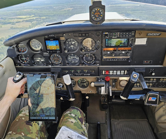
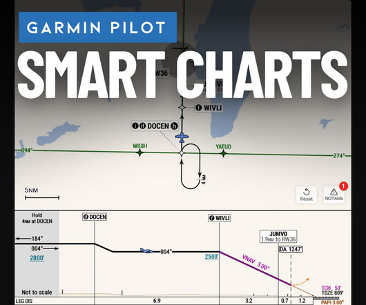
The altimeter started slipping. He lost 200 feet before even noticing the descent. If a NOTAM changes the minimums, or if convective SIGMETs pop up along your route, a printed page will not tell you. But what if a NOTAM has changed the frequency? A quick look at winds aloft while planning the descent.

Pilot 104
article thumbnail

Top Apple Watch features and apps for pilots

iPad Pilot News

Get the watch app here. Altimeter+ Display an altimeter flight instrument on your watch. Get the watch app here. ForeFlight This well-designed app displays airport weather, NOTAMs, communication frequencies, runway information and more.

Pilot 52
Insiders

Sign Up for our Newsletter

This site is protected by reCAPTCHA and the Google Privacy Policy and Terms of Service apply.

Trending Sources

article thumbnail

Garmin SmartCharts: a pilot’s guide to interactive instrument charts

iPad Pilot News

and any adjustments to be made (runway lighting out of service, remote altimeter setting, etc.). Bottom right NOTAMs will show only the NOTAMs that are relevant to the approach youre flying, a major convenience at big airports where the list of NOTAMs can be a mile long (meaning you miss a potentially important one).

NOTAMs 59
article thumbnail

ForeFlight vs. Garmin Pilot: 3 key differences to help you decide

iPad Pilot News

These range from passive red badges on flight plan waypoints and approach charts to identify NOTAMs and closed runways, to on-screen pop-ups accompanied by an aural message to make sure the app gets your attention. And the performance planning feature will warn you if computed takeoff or landing distances exceed available runway lengths.

Pilot 105
article thumbnail

How to Brief an Instrument Approach (Step-by-Step)

Pilot Institute

The landing minimums section includes: Minimum descent altitudes. Preflight Planning Some pilots believe an approach briefing means skimming the chart right before descent. Cross-check the chart notes with the destination NOTAMs. Use the weather (along with the NOTAMs) to ensure your chosen approach is still the best choice.

article thumbnail

Pilot’s aviation app directory – 2025 Edition

iPad Pilot News

Altimeter+ Calculates the altitude of your current location via GPS, or from the built-in barometer included on newer iPhones and iPads.Offers Apple Watch app. This app is dedicated to a clean, graphical view of METARs, TAFs and NOTAMs and is perfect for a quick look at the latest text weather from your iPhone, iPad or Apple Watch.

Weather 91