article thumbnail

How to Fly an ILS Approach

Pilot Institute

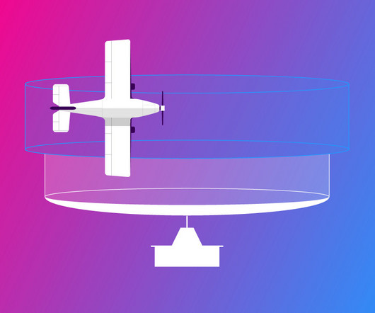
So, how do pilots manage to land their aircraft safely and accurately without even being able to see where theyre going? The ILS (Instrument Landing System) uses radio signals to help pilots align the aircraft accurately on their approach to a runway. Lets learn more about this system! What Is an ILS Approach?

article thumbnail

How to Fly a VOR Approach: Made Easy

Pilot Institute

Are you curious about flying a VOR approach? If you’re aiming to master instrument-rated flying, it’d be valuable to learn about VOR approaches. We’ll cover what a VOR approach is, how to fly it step-by-step, and even whether GPS can replace it in today’s navigation. Ready to make VOR approaches easy?

VOR 52
Insiders

Sign Up for our Newsletter

This site is protected by reCAPTCHA and the Google Privacy Policy and Terms of Service apply.

Trending Sources

article thumbnail

Airport Beacons Explained

Pilot Institute

By 1933, the US Airway Beacon System consisted of more than 1,500 beacons spread across approximately 18,000 miles of airways, guiding pilots safely through the skies at night. Always cross-check airport beacon lights with other navigational information from charts, GPS, or VORs.

VOR 64
article thumbnail

Experience in the Chair: Guiding a Twin Beech Home

Air Facts

The longest runways had front course and back course ILS (Instrument Landing Systems) and an on-field VOR that provided navigation and approach capabilities for aircraft on instrument flights. In the 70s, enroute navigation was usually on VOR Airways (Very High Frequency Omnidirectional Radio).

article thumbnail

The Six Pack: Basic Flight Instruments

Pilot Institute

The Heading Indicator should not be confused with the Horizontal Situation Indicator (HSI), which is an evolution of the Heading Indicator that includes VHF Omnidirectional Range (VOR) and Instrument Landing System (ILS) indications.

article thumbnail

RNAV Approaches Simplified: A Guide for New Pilots

Pilot Institute

Before RNAV, pilots had to rely on radios (NAVAIDs) and antennas on the ground such as VORs (Very High-Frequency Omnidirectional Range) and NDBs (Non-Directional Beacons). But these systems had some problems, like not being able to work over water, or if there was something in the way of the transmitter and the aircrafts receiver.

article thumbnail

Understanding LPV, LNAV, and VNAV: The Easy Way

Pilot Institute

LPV (Localizer Performance with Vertical Guidance) LPV works just like a virtual Instrument Landing System (ILS) approach. These approaches use the Wide Area Augmentation System (WAAS) for ILS-like precision. Always have a backup (ILS/VOR). How does LPV offer ILS-like accuracy? VNAV Benefits Stabilized approaches.