article thumbnail

FAA Continues Transition to Graphical Forecasts for Aviation

Flight Training Central

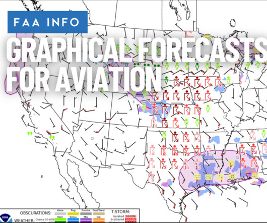
It allows pilots to view ceilings, visibility, precipitation, winds, turbulence, and moreall layered on a dynamic map to enhance situational awareness. The GFA tool , available through the Aviation Weather Center , presents weather data in an interactive, time-based graphical format.

article thumbnail

Business Aviation Weather: International Standard Atmosphere – How It Affects Flight

Universal Weather

It assumes: No moisture (completely dry air) No wind or turbulence Standard pressure, temperature, and density profiles from sea level up through the stratosphere The model is based on the thermodynamic equation and includes tables of values for temperature, pressure, and density at various altitudes. Here’s what you need to know.

Insiders

Sign Up for our Newsletter

This site is protected by reCAPTCHA and the Google Privacy Policy and Terms of Service apply.

Trending Sources

article thumbnail

How High Do Planes Fly?

WayMan

Weather Avoidance : Cruising at these heights keeps planes above turbulent weather patterns and clouds, ensuring smoother flights. Enhanced Comfort : Flying at higher altitudes means smoother rides with less turbulence. Limits on How High Planes Can Go While modern aircraft can fly very high, there are limits to how high planes can go.

article thumbnail

How to Read METAR and TAF Reports

Pilot Institute

m/s) Visibility: 9999 6 or more sm (10+ km) Weather: VCSH VCSH (showers in the vicinity) Clouds: SCT010 BKN030 OVC060 Scattered clouds at 1000 feet AGL, broken clouds at 3000 feet AGL, overcast cloud deck at 6000 feet AGL Ceiling: BKN030 3000 feet AGL Icing: 620509 Light rime in clouds from 5000 to 14000 feet AGL 1.

AGL
article thumbnail

Aviation Weather: Benefits of Using Long-Range Aviation Weather Forecasts

Universal Weather

Knowing where moderate or severe turbulence may exist gives you time to adjust flight levels or reroute altogether. The Value of Long-Range Forecasts Long-range forecasts help operators make better strategic decisions well in advance of day-of-flight.

article thumbnail

Trial by Ice

Air Facts

The hourly sequence report showed Springfield had a ceiling of 100 feet obscured, a visibility of 3/8 mile and fog with a surface temperature of 30 degrees F. The forecast at our arrival time at Jefferson City was for a ceiling of 1,200′ overcast with a visibility of four miles in fog.

VOR
article thumbnail

Who is the pilot in command of your aircraft?

Air Facts

“The instrument conditions, likely turbulence, and increased workload imposed by beginning the approach phase of the flight presented a situation that was conducive to the development of spatial disorientation and a loss of situational awareness.